Artificial Intelligence for Imagery Analysis
Profiler X
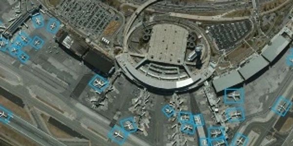
Profiler X is a revolutionary ISR software for automated target detection, interpretation, and management of unlimited objects in aerial and satellite images.
With unique visual object profiling algorithms, we provide deep learning AI tools for automatic multiple target detection, streamlining classification of information for decisive resolution. Profiler X combines an intuitive user interface over an interactive feedback mechanism that continuously increases the precision level of its identification.
• Unlimited target definition and profiling flexibility, enabling the differentiation of objects such as specific vehicles types, building component and more.
• Deployable as a add on tab module for existing GIS imagery management system, such as ESRI Arcmap, SOCET GXP.
• Adjustable to aerial/satellite imagery data received from diverse sensors, thus delivering a significant investment protection to your existing visual imagery.
• Precision adjustments for new operational missions.
• Robust capabilities for changing image setting such as lighting and seasonal affects.
• Includes investigation tools to explore ranked results.
Profiler V
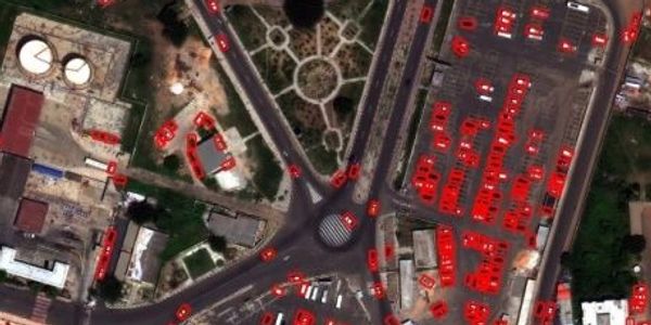
Profiler V is an embedded software that further expands our advanced deep learning technology in the field of live video target acquisition and converting information into insight.
With AI tracking capabilities of multiple static/dynamic objects from moving or fixed video platforms, Profiler V offers advanced capabilities and superior results even in the harshest weather conditions. Our current deployments include multiple aerial platforms equipped with NVIDIA Jetson TX GPU for enumeration of different objects via UAV.
• Unlimited target definition and profiling flexibility, allowing the differentiation of multiple objects and behavioral patterns.
• Directional/zone based profiling that analyzes the number of objects moving per direction or in a designated area.
• C4ISR integration for advanced battlefield situational awareness.
• Roaming video platform integration such as UAV and SUV, ensuring high detection performance and agility.
• Enterprise video integration for modern safe city initiatives, delivering significant insight for emergency management and municipal services.
• Enables consistent database updates and filtered according to rank.